Enhancing navigation safety for small vessels with an electronic chart GPS plotter and autopilot
Copyright © The Korean Society of Marine Engineering
This is an Open Access article distributed under the terms of the Creative Commons Attribution Non-Commercial License (http://creativecommons.org/licenses/by-nc/3.0), which permits unrestricted non-commercial use, distribution, and reproduction in any medium, provided the original work is properly cited.
Abstract
With the ongoing growth of the marine leisure industry, the demand for small vessels and technologies to improve their safety and efficiency has risen. This study focuses on developing an Electronic Chart GPS Plotter system specifically designed for small vessels, addressing challenges like limited fuel capacity, shorter operating ranges, and narrow sea routes. Unlike traditional GPS Plotters, which are optimized for large commercial vessels, this system integrates key route planning algorithms, including the Great Circle Route, Fermat's Spiral, Clothoid, and Cubic Hermite Spline interpolation, ensuring smooth and optimized route connectivity. The system also supports Autopilot functionality by automatically generating optimal routes and dynamically adjusting paths in real-time to adapt to changing environmental conditions. Designed with a user-friendly interface, it provides intuitive controls and real-time feedback, ensuring accessibility for non-experts. Experimental results show that the proposed system significantly improves fuel efficiency, route accuracy, and operational safety, even in challenging maritime conditions. This innovation bridges the gap between existing GPS Plotter limitations and the specific needs of small vessel navigation. By enhancing safety and efficiency, the system contributes to the advancement of marine recreational activities. Future studies will integrate different environmental factors, such as meteorological changes and ocean currents, to further improve the system's effectiveness.
Keywords:
Electronic chart, GPS Plotter, Route Planning, Autopilot1. Introduction
The marine leisure industry has emerged as a significant aspect of recreational activities in contemporary society Consequently, the growing demand for small vessels and recreational boats has been continually driving growth within the industry. Statistics from the Korea Maritime Transportation Safety Authority (KOMSA) show that the number of passengers using fishing vessels grew by around 12% from 2018 to 2020, along with a notable increase in the registration of leisure boats [1]. However, this growth has been accompanied by an increasing trend in maritime accidents. The operations of small vessels inherently carry higher accident risks, highlighting the pressing need for advancements in safety management technologies to address these concerns.
A 2023 report from the Korea Coast Guard indicates that vessels weighing less than 10 tons are responsible for approximately 70% of all maritime accidents, with navigational negligence being the primary cause [2]. This underscores the urgent need for the development of safety technologies specifically designed for small vessel operations and effective route planning tools. Furthermore, current GPS Plotter systems are mainly designed for large commercial vessels, making them often unsuitable for small vessel users [3][4][5]. The path generation algorithms used in large vessels, including the Great Circle Route, Fermat's Spiral, Clothoid, and Cubic Hermite Spline, offer significant benefits in improving the efficiency and stability of maritime navigation due to their unique characteristics [6][7]. However, these algorithms are often applied without considering factors such as fuel efficiency, maneuvering stability, and user-friendliness for small vessels. Due to their restricted fuel capacity and shorter travel range, small vessels require a strong focus on fuel efficiency and precise route planning. However, most GPS Plotters do not adequately consider these specific needs, leading to lower user satisfaction. In addition to the design not accounting for the unique characteristics of marine leisure activities, the current GPS Plotters also face the issue of inefficient electronic chart updates, resulting in the use of outdated information. This represents a significant risk to the safety of small vessel operators, emphasizing the need for a more intuitive and reliable system. Particularly, since many small vessel users are non-professionals, complex interfaces and difficult operating methods can contribute to a higher risk of accidents. Therefore, it is crucial to design GPS lotters that provide a user-friendly and simple operational interface.
To address these issues, this paper seeks to develop an electronic chart-based GPS Plotter system that takes into account the operational characteristics of small vessels. The proposed system has the following key features: First, the system ensures both route efficiency and safety by incorporating curve route planning methods like the Great Circle Route, Fermat Spiral, and Clothoid, Second, design an intuitive and user-friendly interface to ensure that non-experts can operate effortlessly to enhance the overall user experience. Last, consider the possibility of integrating the generated route data with the Autopilot function.
The Autopilot function is enabled by incorporating data from the route generation algorithm into an electronic GPS Plotter. This system is designed for intuitive use by non-expert users, ensuring both fuel efficiency and safety in the operation of small vessels. Moreover, the system is designed to track and adapt routes in real time, enabling flexible reactions to various maritime conditions.
Unlike previous research, this study introduces a system tailored to the unique characteristics of small vessel operations, offering user-friendly and efficient route planning alongside Autopilot functionality. Through this approach, we aim to improve the efficiency and safety of small vessel operations while contributing to the secure advancement of marine leisure activities.
The structure of this paper is as follows: Chapter 2 examines and analyzes existing route planning algorithms and studies applied to vessels. Chapter 3 demonstrates the application of route planning algorithms developed in this study, Chapter 4 focuses on the detailed design and implementation of the navigation system, highlighting key features such as the integration of autopilot functionality and user-friendly interfaces for small vessel navigation. The chapter is divided into two main sections: path planning and autopilot functionality, final system output. Chapter 5 concludes with a discussion of findings and future research directions.
2. Related Work
Different algorithms for generating routes have been studied to plan safe and efficient routes for small vessels in marine recreation. In particular, studies that use curves such as the Great Circle Route, Fermat’s Spiral, Clothoid, and Cubic Hermite Spline are gaining attention. This chapter examines the key studies that have applied these curves.
2.1 Study on the Use of the Great Circle Route
The Great Circle Route is a route planning method that calculates the shortest distance between two points on the Earth's surface, making it especially effective for saving fuel and reducing travel time in long-distance navigation. [8] visually compares the Great Circle Route and Rhumb Line on both a Mercator projection map and a 3D virtual globe, analyzing the distinct geographical features of the Great Circle Route. The Great Circle Route proves to be beneficial in optimizing fuel efficiency for extensive air travel; nevertheless, it necessitates consistent adjustments in course direction owing to its circular path. This study compares the Great Circle Route and the Rhumb Line within a multidimensional visual environment, highlighting the Great Circle Route as a particularly valuable tool in the route planning process. [9] introduces a novel methodology that combines Genetic Algorithm (GA) and Fuzzy Logic (FL) to optimize the number and positioning of waypoints along the Great Circle Route. GA achieves comparable path efficiency with a reduced number of waypoints in contrast to current methods through the global optimization of waypoint placement, while FL dynamically discerns the necessity for supplementary waypoints, thereby avoiding the superfluous creation of waypoints. As a result, the proposed method enhances route efficiency by improving stability and cost-effectiveness, reducing both navigational distance and the frequency of route adjustments. However, the methods did not account for weather conditions or the maneuvering characteristics of vessels, nor did they validate the approach in real-world scenarios involving smaller vessels with more flexible movement trajectories.
2.2 Fermet’s Spiral
Fermat's Spiral is a curve distinguished by its property of maintaining the same area in each revolution, making it a key element in trajectory planning methods. It is often used in path planning scenarios where smooth and gradual curvature changes are critical for effective design. For example, in path planning that uses a spiral route, Fermat's Spiral is employed to create a path that efficiently avoids obstacles or reaches a designated target point. Furthermore, Fermat's Spiral can be used to optimize route design during the docking process of vessels. According to studies, the path based on Fermat's Spiral demonstrates a constant curvature change, which improves vessel stability and helps minimize fuel consumption and turning radius [10].
2.3 Clothoid
The Clothoid curve is defined by a linearly changing curvature, making it especially suitable for facilitating smooth transitions between straight lines and curves. This curve is widely used in various engineering applications, including road design, railroad track design, and vessel docking pathways. In trajectory generation algorithms, the use of Clothoid-based path generation is crucial to ensure the stable navigation of vessels. Studies on route planning have shown that using Clothoid in path design ensures continuous curvature for vessels, minimizing shocks and effectively reducing path tracking errors. Moreover, the Clothoid curve enhances the turning stability of vessels on their trajectories, facilitating safe navigation through narrow sea routes. This helps lower fuel consumption and reduces the impact on the environment [11].
2.4 Cubic Hermite Spline
The Cubic Hermite Spline is an interpolation technique that creates smooth curves by specifying the position and tangent direction at both the start and end points of the curve. This technique is widely applied across various fields, including robotic path planning, ship route design, image processing, and data interpolation. Cubic Hermite Splines are especially valuable in designing trajectories for vessels or vehicles, as they ensure smooth curves while maintaining precise positional data. Furthermore, this technique is utilized in data interpolation for physical simulations like Computational Fluid Dynamics (CFD), curve modeling in structural analysis, and surface design in computer graphics. The paper has demonstrated that Cubic Hermite Splines significantly enhance a ship's fuel efficiency, improve turning stability, and minimize vibration during course adjustments [12].
2.5 An Extensive Overview of Current Research
Current studies utilize the distinct properties of each curve to improve maritime route planning and navigation stability. The Great Circle Route provides a more efficient option for long-distance navigation, while the incorporation of Fermat's Spiral and Clothoid techniques contributes to improved route planning accuracy and stability when navigating turns. Additionally, the Cubic Hermite Spline uses positional and tangent data between two points to create a smooth and continuous curve. However, these studies primarily concentrate on developing route planning systems tailored to the characteristics of large vessels. This high-lights the need to develop a route planning system that considers the unique characteristics of small vessels used in marine leisure activities.
3. System Methodology
This research centered on the development of an electronic chart-based GPS Plotter system specifically designed to address the unique characteristics of small vessels, incorporating Autopilot functionality. Unlike conventional route planning systems intended for large commercial vessels or autonomous ships, this study prioritizes optimizing the system based on the operational requirements and limitations of small vessels. Furthermore, it places a strong emphasis on achieving fuel efficiency, ensuring stability in narrow sea routes, and providing user-friendly automation capabilities.
3.1 Autopilot Implementation via Path Planning
To enable autopilot functionality, the system employs the Great Circle Route for generating straight paths and incorporates Fermat’s Spiral and Clothoid for creating curved paths. Leveraging these route generation algorithms, the system autonomously charts a course from departure to destination, continuously monitors the vessel's real-time position, and automatically adjusts for any deviations from the planned route.
3.2 Path Interpolation Using Cubic Hermite Spline
To resolve discontinuities in data produced by different path generation techniques and ensure stable Autopilot operation, the Cubic Hermite Spline is utilized. This approach generates a smooth and continuous path, reducing abrupt directional changes when adjusting the vessel's course. Consequently, the Autopilot maintains stability during navigation and supports seamless operation.
3.3 User-centered Automation
The electronic chart-based GPS Plotter developed in this study is specifically designed to accommodate non-professional operators of small vessels, ensuring intuitive usability across varying skill levels. Users simply input the starting point and destination, enabling the system to automatically generate the optimal route, which is then executed by the Autopilot function. The generated routes are displayed clearly and intuitively on the electronic map, providing a user-friendly interface that facilitates easy visual understanding of the navigation paths.
To further enhance convenience for non-expert users, the GPS Plotter is designed to function effectively without requiring extensive maritime knowledge. Once the path is generated, the system includes a feature that allows users to verify the route in real-time and makes simple adjustments as needed. For example, if obstacles are encountered along the route or weather conditions change, users can easily create a new route or modify the existing one, with the system promptly updating and communicating these changes to the Autopilot.
Additionally, the system includes a warning notification feature that alerts users to situations requiring course adjustments or potential risks. These automation features empower users to manage their routes safely and efficiently, even in complex situations that may arise during vessel operation. By implementing an electronic chart-based design, the User Experience is significantly enhanced, fostering an environment where small vessel operators can confidently adopt new technologies.
This system fully abstracts the complexities of path planning and autopilot functionality, providing an automated solution that is easy to understand and use, even for non-experts. As a result, the design enhances both safety and convenience in the operation of small vessels.
3.3 Design Considering the Characteristics of Small Vessels
Small vessels often have limited fuel capacity, and they typically operate in narrow sea routes over short distances. Given these constraints, this study adopts a system design that fully accounts for the unique characteristics of small vessels. The Great Circle Route optimizes fuel efficiency on straight path route while Fermat’s Spiral and Clothoid curves provide enhanced turning stability in curved paths. In particular, the continuity of curvature is maintained to ensure the stability of vessels, even when navigating through narrow sea routes.
Additionally, to reduce instability caused by abrupt directional changes during small vessel operations, the maneuvering characteristics of the vessel were integrated into the route generation phase. This approach enhances both operational efficiency and safety, offering practical support to small vessel operators. This design has been optimized through testing in various navigational environments, resulting in a system that is both effective and practical for small vessel users.
The route generation system developed in this study is not only intended for integration with GPS plotters but is also designed with the potential to be expanded for use in autonomous vessel navigation systems. The generated route data is seamlessly integrated with the electronic chart-based GPS Plotter, enabling real-time position tracking and Autopilot functionality. This integration allows small vessel operators to use the system effortlessly, without requiring complex separate configurations.
4. Navigation System Design and Interface
This chapter demonstrates the functionality and design of the developed system within a scenario-based path planning framework. The section highlights how the system processes complex navigation scenarios and translates them into optimized paths through an intuitive and user-friendly interface. Visual representations of the system's features are provided, showcasing the integration of planning algorithms and real-time visualization capabilities. The system interface is designed to interact seamlessly with waypoint data, enabling the generation of safe and efficient paths tailored to various operational contexts. The interface emphasizes practicality and usability, supporting decision-making processes in real-world maritime navigation tasks. By illustrating its adaptability to dynamic scenarios, the system interface exemplifies both technical sophistication and ease of use, making it a valuable tool for maritime navigation and planning.
4.1 Impact of Spline Method on Path Optimization
Path planning plays a pivotal role in navigation systems, serving as a foundation for ensuring safe and efficient travel. This is particularly important in scenarios where precise handling of waypoints and the optimization of routes are critical to operational success. Effective path planning not only minimizes travel time and fuel consumption but also enhances the overall safety and stability of navigation systems. To investigate the capabilities and benefits of the spline method in addressing these challenges, analyses were conducted using two distinct datasets: Scenario 1 and Scenario 2.
Each dataset was designed to reflect path planning requirements in different operational contexts, allowing for a comprehensive evaluation of the spline method’s adaptability and performance. The study compared two types of paths within each scenario: the original paths, which utilized straight-line connections between waypoints, and the spline-generated paths, which employed smooth curves to enhance continuity and flow. These comparisons aimed to highlight the differences in efficiency, safety, and navigational quality between the two approaches, providing valuable insights into the practical advantages of the spline method in diverse conditions.
Figure 1 shows the original path (represented by red lines), which refers to a navigation route constructed using straight-line connections between waypoints. Waypoints are represented as coordinates (x, y), where x indicates longitude and y indicates latitude. This approach results in abrupt directional changes at each waypoint, creating navigational inefficiencies that require frequent and significant maneuvers. Such characteristics can lead to increased fuel consumption, extended travel times, and decreased overall stability during navigation.
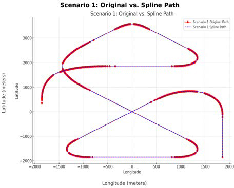
Scenario 1: The original path (red) uses straight lines, while the spline path (blue) uses smooth curves.
The spline path (represented by blue lines), on the other hand, refers to a navigation route that uses smooth, continuous curves to connect waypoints. This method effectively eliminates sharp transitions by prioritizing continuity and natural flow, providing a safer and more efficient route. It simplifies navigation by reducing the need for abrupt steering adjustments, making the path easier to follow. Furthermore, the smoother trajectory contributes to reduced operational strain on navigation systems and vessels, ensuring a more stable journey.
Figure 2 shows Scenario 2, the original path demonstrates similar drawbacks but with additional challenges due to densely distributed waypoints. The straight-line approach results in visually cluttered paths, particularly in regions where waypoints are closely spaced. This clutter increases navigational complexity and creates unnecessary angular deviations, further exacerbating the challenges of efficient navigation.
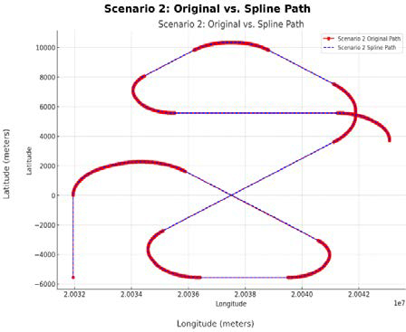
Scenario 2 The original path (red) uses straight lines, while the spline path (blue) uses smooth curves.
The spline path in Scenario 2 addresses these limitations by generating smooth, predictable curves, even in dense waypoint regions. This results in a simplified path structure that enhances usability and reduces visual clutter. The spline method ensures that the path remains easy to interpret, even in complex environments. Moreover, the curved path enhances navigational precision and stability, particularly in scenarios requiring tight maneuverability.
The findings from both Scenario 1 and Scenario 2 emphasize the effectiveness and rationality of the spline method in overcoming the limitations associated with straight-line path planning. In both cases, the spline method demonstrates significant advantages. By eliminating abrupt directional changes, it reduces navigational risks and ensures smoother transitions between waypoints, greatly enhancing safety. Furthermore, the spline path minimizes angular deviations and unnecessary directional shifts, leading to optimized fuel consumption and reduced travel time, which improves overall efficiency. The method also shows strong adaptability to varying waypoint densities and path complexities, highlighting its robustness in diverse navigational contexts.
The spline method significantly improves path planning by addressing critical challenges related to safety, efficiency, and scalability. Its ability to generate smooth and continuous paths in different scenarios underscores its importance in modern navigation systems. Future research should aim to integrate real-time adaptive spline algorithms to further enhance its practicality and flexibility in dynamic maritime environments.
4.2 Autopilot Interface
Autopilot systems play a crucial role in modern navigation by automating essential control functions, such as heading and speed regulation. These systems enhance navigational precision, reduce operator workload, and improve overall efficiency, especially in dynamic maritime environments. The interface of the Autopilot system is primarily designed for inputting vessel specifications, which influence the vessel's initial behavior but are not directly connected to the Autopilot control system. The Autopilot operates independently, continuously calculating and adjusting heading direction and speed based solely on real-time sensor inputs. By integrating advanced control algorithms, such as self-tuning mechanisms, Autopilot systems can dynamically adapt to vessel dynamics and environmental conditions, ensuring optimal performance.
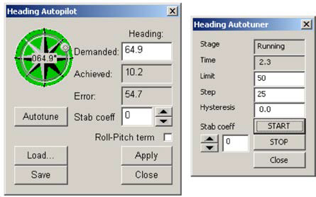
Figure 3 shows Heading Autopilot interface. The Heading Autopilot system enhances navigational precision by providing automated and manual control over the vessel’s heading. The system integrates intuitive user interfaces and advanced control mechanisms, including a self-tuning capability and manual adjustment options, to ensure flexibility and efficiency in operation. The Heading Autopilot interface displays key metrics such as the demanded heading, achieved heading, and the resulting error, allowing users to monitor and adjust performance as needed. The stability coefficient can be fine-tuned to optimize the system’s behavior, balancing responsiveness and stability. Low values may lead to excessive rudder movements, while higher values enhance stability but could cause sluggish responses.
The interface includes an "Autotune" button, which opens the autotuning window to calibrate control parameters automatically. Users can also adjust the heading by dragging the pointer on the heading knob or entering a precise value directly into the edit box, applying changes with the "Apply" button. During operation, the Heading button on the main console and the heading knob illuminate green, indicating that the system is active.
The autotune process uses step-response analysis to learn the vessel’s dynamics and optimize autopilot parameters. If the heading controller shows instability or excessive rudder adjustments after tuning, the stability coefficient can be incrementally increased for better performance. However, excessive increases in the stability coefficient may lead to slower system responses. Overall, the Heading Autopilot system combines advanced automation with user-friendly controls to improve safety, efficiency, and operational stability. It provides a reliable solution for precise navigation, with potential for further enhancements through integration with adaptive algorithms for real-time adjustments in dynamic maritime conditions.
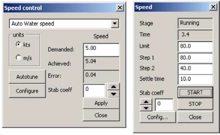
Figure 4 shows Speed Autopilot interface. The Speed Autopilot system provides automated control over the vessel's velocity, working in conjunction with the Heading Autopilot to deliver comprehensive navigation management. It utilizes a self-tuning algorithm that dynamically learns the vessel's behavior to optimize autopilot parameters, ensuring precise and efficient speed regulation in various operational conditions. The Speed Control interface offers essential tools for monitoring and controlling the vessel's speed.
Users can select between units such as knots or meters per second, monitor demanded and achieved speeds alongside the error value and adjust the stability coefficient to balance system responsiveness and stability. The interface also includes an "Autotune" button that opens a dedicated window for automated calibration, as well as options for precise speed input and manual adjustments. The autotuning process uses a step-response algorithm to analyze the speed-time profile resulting from changes in output values. By assessing this data, the system determines the optimal parameters for stable and accurate speed control. During operation, the speed control system requires a non-zero output to maintain a non-zero speed, ensuring continuous propulsion adjustments even with minor speed changes. To enable or disable speed control, the Speed button on the Instrument View must be active, and the Speed Control dialog can be accessed via the menu bar or by right clicking the Speed button. Access to these features requires Engineer or higher access privileges. Overall, the Speed Autopilot system integrates self-tuning algorithms and a user-friendly interface to enhance velocity control, complementing the Heading Autopilot for a complete navigation solution. Its robust design ensures adaptability to dynamic maritime conditions, with future potential for integration with real-time environmental feedback to further optimize performance.
4.3 GPS Plotter Display on an Electronic Chart
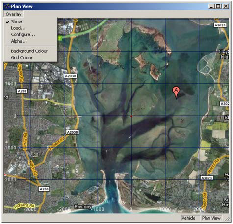
Figure 5 shows system output, showcasing the integration of a Geotiff image overlay within the Plan View window to enable efficient and user-friendly path planning for small vessels. This interface overlays GPS plotter data onto an electronic chart, providing a highly interactive and precise navigation environment. Key features of the system include the ability to load Geotiff images with geographic data directly into the Plan View or Chart View windows. This ensures that images are accurately placed in their corresponding geographic locations. The overlay functionality allows users to toggle image visibility, configure calibration, and adjust transparency dynamically using the Alpha dialog. The transparency feature is particularly valuable as it enables simultaneous visualization of chart information and overlayed imagery, enhancing situational awareness. Furthermore, the background and grid color settings provide additional customization to suit different user preferences or environmental conditions.
This final implementation exemplifies the system’s capacity to support user-friendly and efficient path planning. By combining an electronic chart with a GPS plotter overlay, the system offers small vessel operators a streamlined tool for navigation and route optimization. The Geotiff integration not only enhances the precision of the planning process but also ensures compatibility with diverse geographic contexts, making it a robust solution for modern maritime navigation.
5. Conclusion
This study developed and implemented an electronic chart-based GPS Plotter system designed to improve the efficiency and safety of small vessel operations. To overcome the limitations of conventional GPS Plotter systems, which are primarily designed for large vessels and fail to account for the operational characteristics of small boats, this study has developed a route generation and autopilot function that incorporates the unique features of small vessels, such as narrow sea routes, limited fuel capacity, and short navigation distances.
The path planning in this study employed well-established path generation algorithms, including the Great Circle Route, Fermat's Spiral, and Clothoid, while utilizing Cubic Hermite Spline to provide smooth and continuous transitions between paths. The integration of these algorithms allows small vessels to maintain optimal routes and navigate safely across diverse marine environments. Specifically, the route planning data is seamlessly integrated with the electronic chart-based GPS Plotter system, ensuring reliable execution of Autopilot functions along with real-time location tracking.
This system provides intuitive route creation and management features through a user-friendly interface, designed for easy use by non-expert users. With minimal input, users can automatically generate optimal routes, and the ability to verify and modify the route in real-time allows for flexible responses in situations that require adjustments. As a result, users can maximize operational efficiency while ensuring safety.
This study has enhanced the safety and convenience of the marine leisure industry by developing a GPS Plotter optimized for small vessel operations, along with autopilot functionality. However, a limitation of this study is that it does not fully address dynamic factors, such as weather changes, external obstacles, and ocean currents all of which can influence navigation in the marine environment. Future research will aim to enhance path optimization algorithms by integrating these dynamic factors and will involve validating the system's performance through comprehensive real-world maritime trials.
In conclusion, this study introduces a new approach to designing electronic chart-based GPS Plotters that provides valuable support to small vessel users and is expected to improve the safety and efficiency of marine leisure activities.
Acknowledgments
Following are results of a study on the "Leaders in Industry-university Cooperation 3.0" Project, supported by the Ministry of Education and National Research Foundation of Korea.
Author Contributions
Conceptualization, S. D, Lee; Methodology, S. D. Lee; Hardware, J. W. Lee and G. J. Yoo; Formal Analysis, J. H. Kim and J. W. Lee; Investigation, J. W. Lee and G. J. Yoo; Resources, J. W. Lee, and G. J. Yoo; Writing-Original Draft Preparation, S. D. Lee and J. W. Lee; Writing-Review & Editing, J. H. Kim; Visualization, J. W. Lee and G. J. Yoo; Supervision, S. D. Lee; Project Administration, S. D. Lee; Funding Acquisition, S. D. Lee.
References
- Korea Maritime Transportation Safety Authority. (2023). “Marine Accident Statistics by Vessel Type” KOMSA. Available: https://www.komsa.or.kr/, .
- Public Data Portal. (2023). “Korea Coast Guard_Maritime Distress Accident Detailed Data Status.” Available: https://www.data.go.kr/data/3043630/fileData.do, .
-
P. Chen, Y. Huang, E. Papadimitriou, J. Mou, and P. van Gelder, “Global path planning for autonomous ship: A hybrid approach of Fast Marching Square and velocity obstacles methods,” Ocean Engineering, vol. 214, 107793, 2020.
[https://doi.org/10.1016/j.oceaneng.2020.107793]

-
Ü. Öztürk, M. Akdağ, and T. Ayabakan, “A review of path planning algorithms in maritime autonomous surface ships: Navigation safety perspective,” Ocean Engineering, vol. 251, 111010, 2022.
[https://doi.org/10.1016/j.oceaneng.2022.111010]

-
E. Eliopoulou, A. Papanikolaou, and M. Voulgarellis, “Statistical analysis of ship accidents and review of safety level,” Safety Science, vol. 85, pp. 282-292, 2016.
[https://doi.org/10.1016/j.ssci.2016.02.001]

-
Y. Huang, Y. Xiao, H. Wang, and H. Yi, “A rapid globe-wide shortest route planning algorithm based on two-layer oceanic shortcut network considering great circle distance,” Ocean Engineering, vol. 287, 115761, 2023.
[https://doi.org/10.1016/j.oceaneng.2023.115761]

- Đ. Mohovoć, R. Mohović, and I. Rudan, “Ship track and speed model in case of steering gear breakdown with rudder remaining fix at non zero angle,” Brodogradnja: An International Journal of Naval Architecture and Ocean Engineering for Research and Development, vol. 63, no. 2, pp. 117-124, 2012.
-
Q. Zhang and K. Zhang, “2D and 3D webpage visualization of the great circle and rhumb line,” in Proceedings of 23rd International Conference on Geoinformatics, pp. 1-3, 2015.
[https://doi.org/10.1109/GEOINFORMATICS.2015.7378611]

-
T. H. Hsieh, Q. Meng, B. Han, S. Wang, and X. Wu, “Optimization of waypoints on the great circle route based on genetic algorithm and fuzzy logic,” Journal of Marine Science and Engineering, vol. 11, no. 2, pp. 358, 2023.
[https://doi.org/10.3390/jmse11020358]

-
A. Lekkas, A. R. Dahl, M. Breivik, and T. I. Fossen, “Continuous-curvature path generation using Fermat's spiral,” Clothoid-Based Path Planning for Autonomous Vehicles in Dynamic Environments, 2013.
[https://doi.org/10.4173/mic.2013.4.3]

-
J. A. Silva and V. Grassi, “Clothoid-based global path planning for autonomous vehicles in urban scenarios,” in Proceedings of IEEE International Conference on Robotics and Automation (ICRA), pp. 4312-4318, 2018.
[https://doi.org/10.1109/ICRA.2018.8461201]

-
A. M. Ayebire, I. Kaur, D. A. Alemar, M. S. Manshahia, and S. Arora, “A robust technique of cubic Hermite splines to study the non-linear reaction-diffusion equation with variable coefficients,” AIMS Mathematics, vol. 9, no. 4, pp. 8192-8213, 2024.
[https://doi.org/10.3934/math.2024398]


