Implementation of a real-time small draft observation system using triangular correction algorithms
Copyright © The Korean Society of Marine Engineering
This is an Open Access article distributed under the terms of the Creative Commons Attribution Non-Commercial License (http://creativecommons.org/licenses/by-nc/3.0), which permits unrestricted non-commercial use, distribution, and reproduction in any medium, provided the original work is properly cited.
Abstract
Herein, at the request of the Korea Coast Guard, we propose a LoRaWAN-based small observation system that can quickly find survivors at sea by measuring the speed, direction, and distance between a ship and mobile device in real time. This system was implemented and verified in the early stages of rescue after maritime vessel accidents. GPS signals often transmit considerable errors; therefore, correction algorithms using an improved triangulation method are required to accurately indicate the direction of the currents in real time.
The remainder of this paper is organized as follows: Section 1 describes rescue operations following maritime accidents. Chapter 2 describes the methods and theories for GPS triangulation and features of LoRaWAN communication. The critical distance error-correction algorithm for GPS signals and its improvement are explained and expanded. Section 3 discusses the design and analysis of the small-draft observation system. Section 4 presents the testing and implementation of both ship-to-shore environments. Finally, Section 5 concludes the study with expected impacts and future effects.
Keywords:
Multi-GPS, Triangulation method correction algorithm, Ocean current, Drift observation system, LoRa communication1. Introduction
Ship accidents in marine environments have continued to occur without a decrease in frequency. In Korea, large-scale accidents resulting in loss of life have occurred, such as the Sewol ferry disaster, as well as numerous incidents of damage caused by collisions, rollovers, fires, and other accidents involving small- and medium-sized ships. In the event of an accident, maritime police utilize an “automatic identification system (AIS)” to respond quickly and conduct search and rescue operations within a critical time period. However, the current systems for ensuring the safety of human life and conducting life-saving activities remain insufficient [1][2].
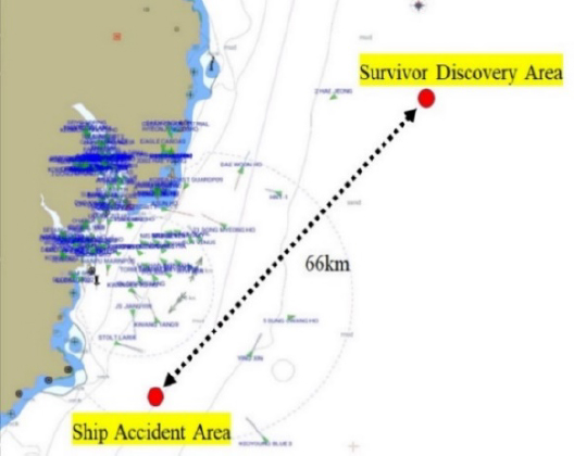
Rescuing survivors of maritime accidents is difficult because the actual rescue point for the victims is often located far from the site of the ship accident. This phenomenon occurs because survivors can drift away due to ocean currents. A real-time sea-current prediction system is needed to quickly rescue survivors in such situations.
To address the challenge of rescuing survivors who have drifted from the Korean shore, the National Oceanic and Atmospheric Research Institute developed a drift prediction system in 2015. However, this system is based on ocean-current data observed from a small number of weather stations located at sea and does not account for the complex interplay of factors such as currents, tides, waves, and weather changes at the actual accident site, making it difficult to predict the location of missing persons [3].
Therefore, the current flow in real-time based on the accident point should be measured and analyzed to estimate the location of survivors when searching for missing persons at the scene of a maritime vessel accident.
This paper presents the development of a portable, movable ocean-current measurement system that can quickly measure the speed and direction of ocean currents using GPS in the early stages of maritime accidents. A prototype of the system was implemented, and its accuracy and efficiency were verified through actual tests in a maritime environment.
2. Related research
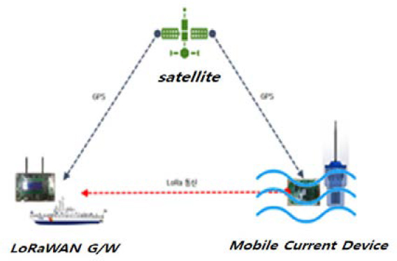
In this study, a device capable of transmitting and receiving real-time ocean-current measurements while simultaneously receiving multiple GPS values was developed to predict the direction of search and rescue operations during emergencies, such as maritime accidents. To achieve this, a system using LoRa, a low-power, long-range wireless communication technology, was constructed. The device also features a seawater flow drift observation device (transmitter) equipped with more than three GPS stations to reduce errors and enable triangulation for accurate location tracking. This system provides a reliable solution for the quick transmission and reception of accurate location information during maritime rescue operations.
2.1 Positioning technique
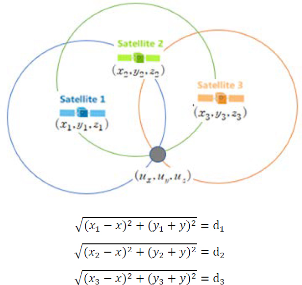
Various positioning techniques have been developed, but the most common is the triangulation technique used in GPS. This method measures the distances to three satellites to determine the receiver’s location. In this study, more than three GPS sensors were installed, and the double difference method was applied twice. The seawater flow drift observation device may move due to ocean currents, and the average GPS values provide accurate location data for drift prediction of the system.
In this study, a relative positioning technique was used to obtain more accurate location information by applying the values received from three or more GPS devices twice in a row using the double-difference method. This approach improves the accuracy of the location information obtained compared to a single application of the double-difference method. The GPS reception data signal was verified using the standard deviation and threshold T. Because GPS signals can sometimes transmit very large errors that cause fatal errors in speed and distance calculations, GPS signals that fall above a certain period and are averaged out of the N GPS signals received are not used for calculation. Measurement theory of satellite GPS data is as follows:
| (1) |
Absolute positioning, also known as global positioning, is mainly used in navigation systems such as cars, ships, and airplanes because it can be measured anywhere on Earth with just one mobile station. The precision of the absolute positioning is approximately 100 m using the C/A code and standard L1 to 1 frequency reception with SA activation. However, SA is currently released to achieve a higher accuracy of 20–30 m, and even higher accuracy can be obtained using the P code.
The precision of low-cost commercial receivers that use the C/A code of GPS signals to determine location ranges from tens to hundreds of meters. However, achieving a precision of less than 1 m is highly unlikely when a receiver uses an encrypted P code. In areas requiring high-precision positioning of several centimeters or less, such as geodetic and perceptual fluctuation surveillance, relative positioning techniques are used to overcome the limitations of absolute positioning with GPS. These techniques involve performing GPS observations simultaneously from a precise point and another point where positioning is required. The simultaneous measurement significantly increases precision with the data processing of carrier waves, which is a high-frequency diffusion spectrum from two receivers.
The GPS receiver uses navigation data received from the satellites to calculate the user's location and speed. These navigation data include information such as the satellite's line of sight, orbit, and correction model values. Using this information, the GPS receiver calculates the location of the satellite and estimates the time required for the signal to travel from the satellite to the user. The GPS receiver can determine the user’s location by calculating the distance between the satellite and user.
However, the distance calculated by the GPS may differ from the actual distance. Multiple GPS devices were used to correct the error range. Triangulation involves measuring the angles between the base and the other two sides of a triangle, as well as the lengths of the sides, to determine the coordinates and distance of a point relative to two reference points.
The point at which the three circles intersect can be determined using the provided equation, given the distances between the GPS coordinates of the two received coordinates and the fixed coordinates (x1, y1), (x2, y2), and (x3, y3).
When calculating the coordinate value using the distance between two connected GPS units, errors can occur owing to consecutive time differences and phase displacements. These errors are more pronounced with low-cost GPS units, and triangulation using multiple GPS units is necessary to correct them.
2.2. Seawater flow drift observation system
The direction between the two coordinates is calculated using the following equation: θ = atan 2(sin Δλ·cos φ1, cos φ1·sin φ2−sin φ1·cos φ2·cos Δλ)φ1, λ1 indicates the starting point, and φ2 and λ2 indicate the arrival time. Δλ is a difference between λ1 and λ2. The speed is calculated using the time of the GPS signal, and the distance of the movement is calculated from point 2. In some cases, errors in speed and average travel distance occur owing to errors in GPS signals; therefore, if the speed increases rapidly at sea, it is judged as an error in GPS signals, and the speed is recalculated when the next signal is received.
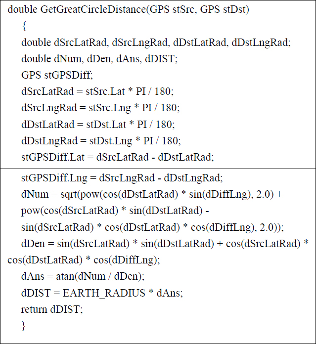
The distance between the previous and current GPS coordinates was calculated using the great circle distance method. Each function value was proportional to the data reception distance, and the average GPS values were obtained from three points corrected by triangulation.
3. Design and implementation
3.1 Design of the small draft observation system
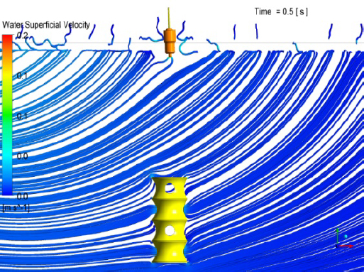
The seawater flow drift observation device was designed to facilitate movement and operation according to user requirements, based on a generalized draft booth shape. For the prototype, the surface finish or maintenance of the material were not considered. To ensure proper buoyancy and line of sight (LOS) for the 700–900 MHz non-directional antennas and to prevent any impact on communication quality during drift, the device was manufactured based on weight, current analysis results, and center of gravity considerations.
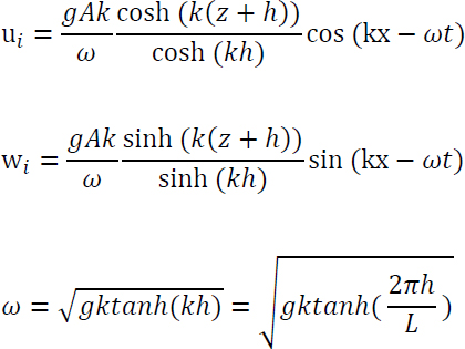
The shape and center of gravity of the mobile unit were determined according to the flow of ocean currents from waves, and the following flow equation was applied to model waves occurring in the ocean: The tetrahedral and prism grid systems used 1,050,000 nodes and 4,760,000 elements, respectively.
The testbed consisted of a prototype ocean flow drifting observation device, transmitting antenna and module, battery for the transmitter, receiving antenna and module, battery for the receiver, and terminal (laptop) to view and process the received data. The real-time latitude value, hardness value, speed, direction, and distance of the transmitter were displayed, and the unit indication of latitude and hardness were indicated as latitude Lat and longitude Lng; the expressed content of the buoy was indicated by the direction given in degree, minute, and second (00.00.00).
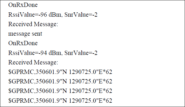
To verify the received data, the lengths of the UTF-8 strings and byte counters were calculated and confirmed. The GPS data were also calculated at a size of 65 bytes. During testing, the transmitted data and received values were confirmed to be within the range of 293–537 bps, based on the set values (SF11 and SF12) of the seawater flow observation device. In addition, information such as the Rx signal strength, SF, Tx power inquiry, SF/BW/CR setting, and RX/TX time (local time) could be outputted. A sequence information log indicating the GPS location was generated to confirm whether the data had been received.
The method of transmitting the location from a current measurement device to an electronic chart system receiver includes information-sending methods in the NMEA0183 format, in the form of an AIS message, and in its own format.
In this study, the GPRMC of NMEA 0183 was applied. The NMEA 0183 protocol starts with a $ sign; the following two letters after $ represent the type of equipment; three characters such as RMC represent the type of intensity; and each data field is divided by commas (,). When the data field is complete, the XOR of all characters is calculated, and the byte value is written in hexadecimal format, followed by *. The termination of the intensity is indicated by ASCII 13 (carriage return) and 10 (line feed), which use two bytes.
3.2 LoRaWAN-based small draft observation system
Long range, abbreviated as LoRa, represents the most prominent characteristic of LoRa communication and is the unlicensed band’s long-distance communication distance. The communication structure adopts a star topology based on the Aloha protocol, with a propagation reach of up to 20 km and a communication speed of approximately 0.3 kbps. Considering speed and transmission time, a range of 2 km was used. Other features include low energy consumption, multisensor functions, encryption, safe two-way communication, and mobility.
The transmission distance and speed of the LoRa terminal vary with the applied diffusion coefficient. Table 1 shows the correlation between the diffusion coefficient and reception sensitivity of low-power, wide-area IoT LoRa gateways commercialized in Korea.
GPS can be classified as stand-alone GPS with a location accuracy of 25 m, differential GPS (DGPS) with a location accuracy of several meters, and carrier-phase differential GPS with a location accuracy of the centimeter level.
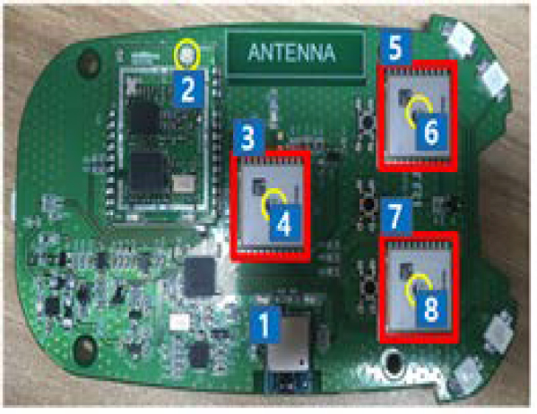
To improve the accuracy of predicting the locations of marine accident survivors, a terminal equipped with multiple GPS-receiving modules was developed. This is because, when using a single module, the coordinates may be off by approximately 10–20 meters. The prototype was equipped with three GPS receiving modules (4), (6), and (8), as shown in Figure 7, to correct the positioning errors. A 5V–12V lithium-ion battery was installed, considering the size, weight, and power consumption of the terminal. The LoRa communication module was designed and manufactured to meet the frequency requirements of 917–923.5 and to use the listen-before-talk (LBT) function.
4. Conclusion
In this paper, the characteristics and main parameters of GPS surveying techniques and LoRaWAN communication are described. A prototype of a seawater flow drift observation device was designed and implemented. This system, which can predict the rapid flow of ocean currents (speed and direction) in the early stages of an accident at sea, is expected to be used as a systematic structure search tool in the case of an emergency for the rescue of distressed marine accident survivors.
The proposed system processes on-site data by utilizing LoRa communication, which has the characteristic of enabling communication when transmitting and receiving data even in areas where Wi-Fi communication is not available owing to low power or on low-cost small and medium-sized ships. It is also a communication method that can transmit data up to 14 km, and it will be very advantageous for commercialization because of its highest preference among IoT technologies. LoRa communication has characteristics such as low power, long-distance transmission, multiple sensors, and encryption. As the test product can be linked to the ship standard network (NMEA0183), its application can be expanded to various products.
Academia has the limitation of having few professionals or large equipment, such as ships, to perform prototype production and prototype performance verification tests required for the development of measurement devices that utilize satellite navigation systems (e.g., GPS) for the rescue of persons in distress.
In the wake of the Sewol Ferry disaster, the government is actively interested in establishing and strengthening systems to respond quickly to maritime emergencies, and the development of technology for a current measurement device that uses GPS for rescue purposes is essential. Despite the various safety policies implemented by the government, large-scale marine accidents accompanied by human casualties continue to occur, and a fundamental re-inspection of safety measures is necessary. As marine tourism increases, continued efforts are needed to develop related technologies, such as those required for securing precise waterway information to determine the risk of marine accidents faced by small or passenger ships as they pass through coastal waters.
Author Contributions
Conceptualization, Y. G. Kang; Methodology, Y. G. Kang and J. H. Yim; Software, Y. G. Kang; Formal Analysis, W. J. Lee; Investigation, S. W. Kim; Resources, S. W. Kim; Data Curation, J. H. Yim; Writing-Original Draft Preparation, Y. G. Kang; Writing-Review & Editing, Y. G. Kang; Visualization, Y. G. Kang and W. J. Lee; Supervision, J. H. Yim; Project Administration, Y. G. Kang; Funding Acquisition, Y. G. Kang.
References
- S. T. Nam, C. Y. Jin, and D. G. Kim, “A priority analysis on mobile telecom internet of things using the AHP (analytic hierarchy process),” Journal of the Korea Institute of Information and Communication Engineering, vol. 21, no. 6, pp. 1191-1196, 2017.
- W. C. Jung, S. S. Lee, and J. H. Park, “Design of optimal snow melting system with snowfall image processing based on the IoT technology,” Asia-pacific Journal of Multimedia Services Convergent with Art, Humanities, and Sociology, vol. 5, no. 6, pp. 521-530, 2015.
-
H. Lee and D. Lee, “A study on localization system using 3d triangulation algorithm based on dynamic allocation of beacon node,” the Journal of Korean Institute of Communications and Information Sciences, vol. 36, no. 4B, pp. 378-385, 2011 (in Korean).
[https://doi.org/10.7840/KICS.2011.36B.4.378]

- S. Lim and K. Lee, “Preventing communication disruption based on LoRaWAN,” 2017 Proceedings of Symposium of the Korean Institute of Communications and Information Sciences, pp. 509-510, 2017.
- S. Y. Kim et al., “Wide range IoT technology and standardization based on LPWA,” Electronics and Telecommunications Trends, vol. 31, no. 2, pp. 95-106, 2016.
-
B. C. Fargas and M. N. Petersen, “GPS-free geolocation using LoRa in low-power WANs,” 2017 Global Internet of Things Summit (GIoTS), Geneva, Switzerland, pp. 1-6, 2017.
[https://doi.org/10.1109/GIOTS.2017.8016251]


